Interactive Maps
Mount Vernon to Anacostia River
Search Potomac Sites
Also Explore
| The Hudson River Guide | The Delaware River Guide |
| The Connecticut River Guide | |
Mather Gorge
National Park Service Site
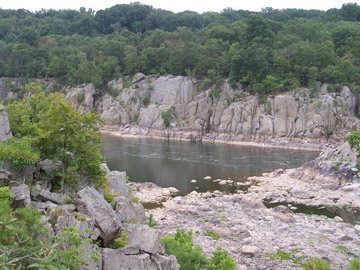
Around canal mile 13.5, an arrow-straight, narrow gorge appears to have sliced through solid rock. Mather Gorge funnels the entire Potomac into a 100-yard wide stream. The gorge is popular for whitewater canoeists and kayakers, but very dangerous for the inexperienced.
The Potomac here is wild and remote, although it is less than a dozen miles from the White House. From the area just below Great Falls downstream, the river has some of the best "big water" paddling in Maryland, with larlge waves, surging eddies, and sustained rapids. Access is from the Sandy Beach area south of the Great Falls Tavern; Angler's Inn, along MacArthur Blvd. across from the Old Anglers Inn; and at Carderock, from the Carderock picnic area; and at Lock 10 along the Clara Barton Parkway on the C&O Canal. On the Virginia side, paddling access is from Fisherman's Eddy at Great Falls Park, and at Rock Island south of Great Falls. These access points involve carrying boats down a trail to the river.
Favorite rapids include:
- O-Deck--Class III near Fisherman's Eddy
- Fishladder--Class II-III south of Great Falls
- S-Turn--Famous for converging currents
- Rocky Island--Class II-III
- Wet Bottom Chute--Class II
Suggested Links
Contact Information
C&O Canal National Historical Park
11701 MacArthur Blvd.
Potomac MD 20854
Website