Interactive Maps
Mount Vernon to Anacostia River
Search Potomac Sites
Also Explore
| The Hudson River Guide | The Delaware River Guide |
| NEW! The Connecticut River Guide | |
Little Falls
Washington River Monitoring and Recreation Site

Little Falls is the end of a 10-mile stretch of rapids, falls, and swift water where the Potomac begins the transition from a free-flowing stream to a tidal estuary. At Little Falls (10 miles downstream from Great Falls), the tidal influence is actually felt. Little Falls is also the river's "head of navigation," meaning that ships cannot navigate the river any farther upstream.
The location played a key role in the choice of a site for the Nation's Capital. In 1790, Congress enacted a law directing George Washington to select a site for the seat of government for the United States to be somewhere on the Potomac between the Anacostia River and Conococheague Creek (70 miles upstream at the town of Williamsport, Md.). The law was called "The Residence Bill," and it included provisions for assuming northern states' debts from the Revolution in return for supporting the Potomac River site. Thomas Jefferson was involved in negotiating the compromise that resolved several important issues in the early days of the republic. George Washington made the logical choice: locating the city just below Little Falls made it accessible to river and ocean commerce, but at the same time it was far enough upstream to present problems for any foreign invader. (Of course, navigating the river was not a problem for the British, who burned the White House during the War of 1812, only two decades later).
Little Falls was the site of the Little Falls Skirting Canal, one of the canals built by Washington's Patowmack Company prior to the development of the C&O Canal.
Current stream conditions are shown in the graph below:
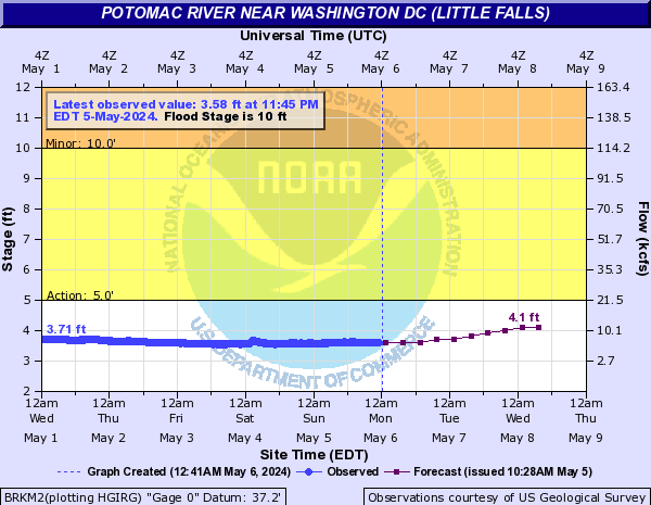
The National Oceanic and Atmospheric Administration (NOAA) has an on-line river forecast service for Little Falls available at this link. The forecast summary is shown below.
Flood Levels and Impacts
These impacts have been estimated by NOAA and FEMA based on flood levels at Little Falls
- 17 Feet: Water overflows the overlooks at Great Falls Park and approaches the lower level of the visitors center. Most of the C&O Canal towpath downstream of Pennyfield Lock is flooded.
- 15 Feet: Most of the C&O Canal towpath from Pennyfield downstream is flooded.
- 14 Feet: Significant portions of the C&O Canal towpath are flooded. The Blockhouse Point Park is flooded. Water reaches the retaining wall at Overlook 1 at Great Falls National Park but does not overtop it.
- 12 Feet: The C&O Canal overflows at the Great Falls Tavern. Water covers the towpath in many areas.
- 11.5 Feet: Water covers the towpath in multiple spots between the Washington Aqueduct Dam and Pennyfield Lock, mileposts 15 to 19 on the C&O Canal.
- 11 Feet: Water covers the towpath between Swains Lock and Pennyfield Lock, mileposts 17 to 19 on the C&O Canal.
- 10 Feet: Water begins to overflow the banks into low lying areas on the Maryland side of the river near Little Falls.
- 9 Feet: Several trails on both sides of the river between Great Falls and the Chain Bridge are flooded and will be closed.
- 7 Feet: Upper portions of the River Trail at Great Falls National Park begin to flood and will be closed.
- 5.5 Feet: Water begins to affect portions of the Billy Goat Trail between Great Falls and Carderock. These trails may be closed.
- 5 Feet: Portions of the Potomac Heritage Trail begin to flood.
- 4.5 Feet: The river reaches danger level for boaters, as defined by the State of Maryland. Conditions for boating will be extremely hazardous.
- 3.5 Feet: The river reaches caution level for boaters, as defined by the State of Maryland. Fast moving water and changing currents will be experienced.
For detailed USGS real-time data on this site, select this link.
Nearby Potomac River Stream Monitors | |
Upstream | Downstream |
Contact Information
National Park Service
Turkey Run Park
McLean VA 22101
703-289-2500
Website