
Hudson River Guide Interactive Maps
| The Upper Hudson | Boat Ramps and Kayak Access |
| The Middle Hudson | Bridges and Ferries |
| The Lower Hudson | Parks and Historic Sites |
| River Railroad Stations | |
Search Hudson Sites
Also Explore
| The Potomac River Guide | The Delaware River Guide |
| NEW! The Connecticut River Guide | |
Federal Lock at Troy
Historic Site
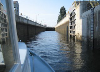
The Federal Lock and Dam at Troy marks the head of tidal waters of the Hudson River and is located at mile 153 of the Hudson River, measuring from the beginning of the Hudson as a Federally Navigable Waterway near the Battery in New York City. The eastern end of the dam contains a lock, commonly called the Federal Lock or (on some charts and publications) the "Troy-US Lock." The lock, which was opened in 1916, has a single chamber and is 520 feet long, 45 feet wide, and 17 feet deep. The major function of the dam is to improve navigability. This is the north end of the tidal Hudson--the Estuary--about 135 nautical miles north of the Battery. This lock lifts about 17 feet. A few miles up is Waterford, where the Mohawk River enters the Hudson and where the Erie Canal starts west.
Suggested Links
Contact Information
U.S. Army Corps of Engineers
1 Federal Lock Access Road
Troy, NY 12180
Website