Interactive Maps
Mount Vernon to Anacostia River
Search Potomac Sites
Also Explore
| The Hudson River Guide | The Delaware River Guide |
| NEW! The Connecticut River Guide | |
Washington Channel
Washington, D.C.

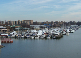
Nearly the entire Southwest area of the District of Columbia was redeveloped during the 1960s. Hundreds of early buildings, many of them run down beyond restoration, were bulldozed and replaced by high-rise and townhouse developments. Along the Washington Channel, the waterfront was rebuilt under federal and city ownership; large restaurants and marinas operate with long-term leases from the city. A one-mile long walkway is provided along the bulkhead from P St. S.W. up the Channel to the Municipal Fish Wharf.
The District government runs the Police and Fire pier for waterfront safety (pier 5) at the southern tip of the developed area. Other piers are used by the Spirit of Washington, the Gangplank Marina, and the Odyssey, a new cruise ship that made its debut in 1995.
The Maine Ave. waterfront area is accessible by Metro. An underground subway stop on the Green Line is at 4th and M Streets S.W., about two blocks from Water Street.
Suggested Links
Contact Information
Culltural Tourism DC
1250 H Street NW
Washington DC 20005
202-661-7581
Website
