Interactive Maps
Mount Vernon to Anacostia River
Search Potomac Sites
Also Explore
| The Hudson River Guide | The Delaware River Guide |
| NEW! The Connecticut River Guide | |
Douglas Point Natural Resources Management Area
U.S. Bureau of Land Management Site
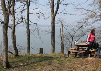
A 500-acre tract of land along the Potomac near Smallwood State Park was acquired by the federal government and the state of Maryland in 2001 and is available for hiking, wildlife viewing, and hunting in season. A 1-mile trail leads to a bluff high over the Potomac shoreline.
The site has had a variety of proposals, ranging from a nuclear power plant to homesite development. The point contains large hardwood forests, archeological sites, wildlife habitats, and a combinbation of wetlands, woodland, and aquatic habitat. The site is managed in combination with another recent Bureau of Land Management property, the Meadowood Farm on Mason Neck in Northern Virginia.
BLM allows beach access and day-use along approximately 1.2 miles of public shoreline. There is a small gravel parking lot along Maryland Route 224 and an accessible trail to the twin chimneys of the Chiles homestead, dating to the late 1700s.
The Douglas Point area is designated as a Maryland Natural Area. For more information, select this link.
Douglas Point is also part of the "Find Your Chesapeake" project of the National Park Service and the Chesapeake Conservancy. Click here for details.
Suggested Links
Contact Information
Bureau of Land Management
10406 Gunston Road
Lorton VA 22079
703-339-8009
Website