Connecticut River Guide Interactive Maps
| The Upper Connecticut | Boat Ramps and Kayak Access |
| The Middle Connecticut | Bridges and Ferries |
| The Lower Connecticut | Parks and Historic Sites |
Search Connecticut Sites
Also Explore
| The Delaware River Guide | The Potomac River Guide |
| The Hudson River | |
William Putnam Bridge
Connecticut River Bridge

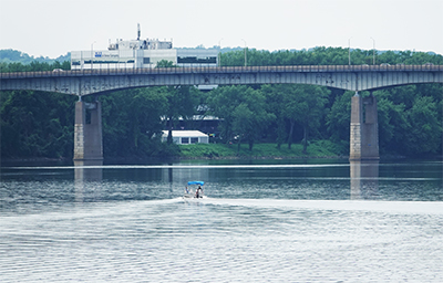
The William H. Putnam Memorial Bridge, also known as the Connecticut Route 3 Bridge, is a significant structure that spans the Connecticut River, connecting Interstate 91 in Wethersfield and Route 2 in Glastonbury. This steel girder bridge is the southernmost crossing of the Connecticut River in the Hartford Area and carries an average of 50,800 vehicles per day. The bridge was built in the late 1950s as part of the Route 3 connector. It underwent a $15 million rehabilitation project in 2013, which included repaving the roadbed, repainting the girders, adding new lighting fixtures, and a new pedestrian walkway. The Connecticut Department of Transportation (CTDOT) is developing plans to further rehabilitate the bridge in Spring 2026.
The Putnam Bridge provides access for the Putnam Bridge Trail and the Great Meadows on the West side. Area on Glastonbury side was reclaimed from a petroleum processing plant in the 1960s.
Suggested Links
Contact Information
CTDOT
Wethersfield, CT 06109
Website
